
Bank Stabilization and Habitat Enhancement
Currently in the schematic design phase, this project aims to revitalize a degraded section of Eighteenmile Creek that passes through the 18 Mile Creek Golf Course in Hamburg, NY. The scope of work includes stabilizing over 5,000 linear feet of shoreline through nature-based solutions and revitalizing 7.8 acres of floodplain habitat through invasive species removal and native plantings. These improvements will enhance habitat value, shoreline resiliency, and water quality without impacting golf course programming.
Project Area and Pre-Construction Conditions
Eighteenmile Creek possesses a rich and diverse set of ecosystems, yet intensifying storms and developmental changes have damaged portions of this important waterway.
The creek is located within the Niagara River/Lake Erie Watershed and has regional significance in its ability to support critical fish and wildlife species. From intact headwater streams supporting native cold-water species of eastern brook trout, to the warm-water fisheries of walleye, yellow perch, and bass at the confluence of Lake Erie, the creek is celebrated by many.
The proposed project area is located within the 18 Mile Creek Golf Course in Hamburg, NY, which falls within the middle reach of the Eighteenmile Creek corridor. The 1.5 miles of Class A (T)† stream that flows through the golf course hosts some of the most degraded riparian conditions along the entirety of the creek.
†DEC stream classifications A, AA, A-S and AA-S indicate a best usage for a source of drinking water, swimming and other recreation, and fishing. Waters with classifications AA, A, B and C may be designated as trout waters (T) or suitable for trout spawning (TS). These designations are important in regards to the standards of quality and purity established for all classifications. See the DEC Rules & Regulations and the Water Quality Standards and Classifications page on the NYSDEC web site for information about standards of quality and purity.

Project location and context.
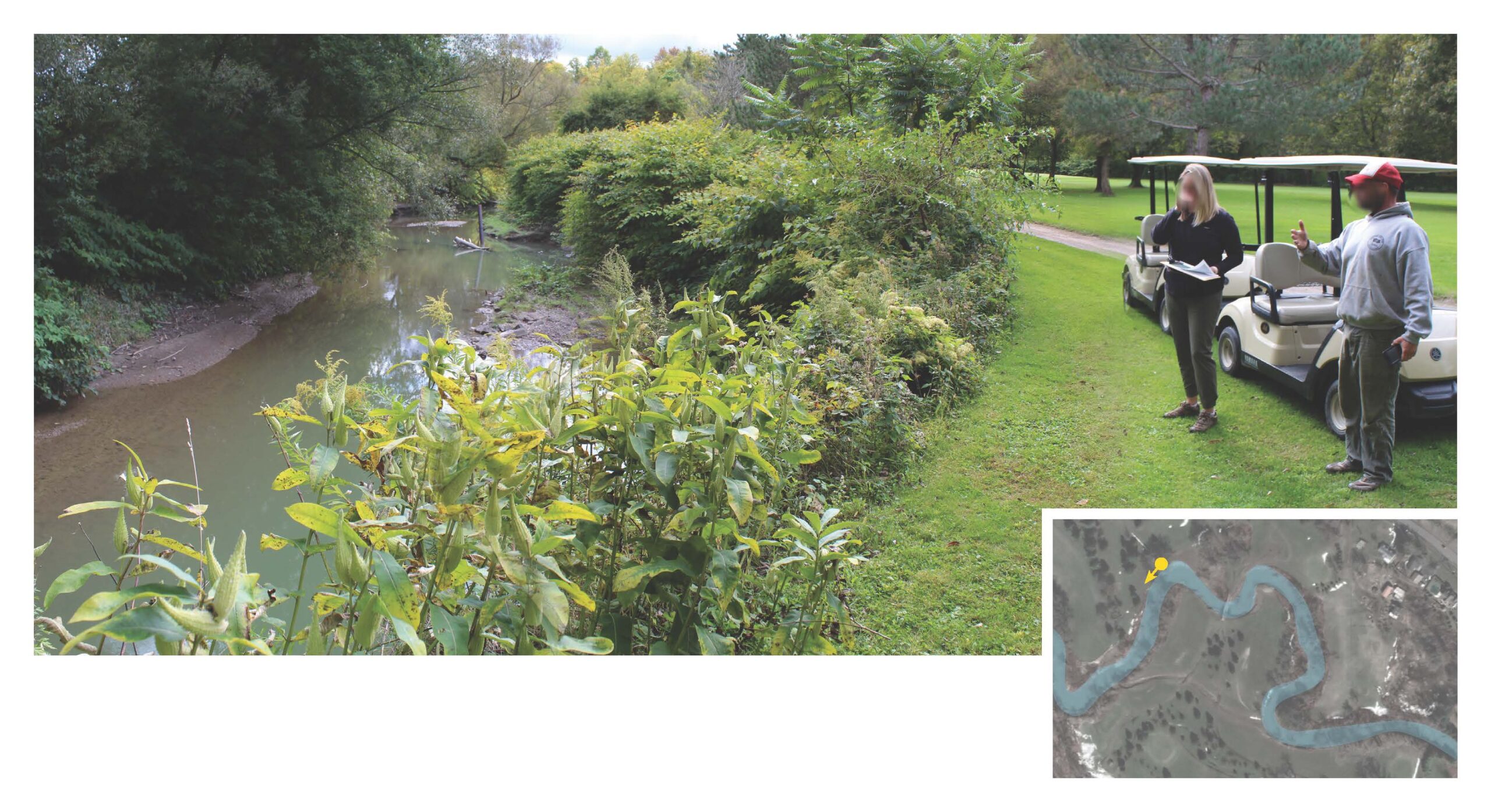
Much of the shoreline within the golf course has experienced accelerated erosion and bank failures due to dramatic modifications to riparian areas and an increased frequency of heavy rain events. Erosion from the failing banks contributes to high turbidity* levels, and in the absence of healthy stream buffers, any fertilizers or pesticides used will flow directly into the creek, further degrading water quality.
These conditions may contribute to the creek’s downgrade to a Class B (T) waterway just downstream of the golf course. Furthermore, the riparian corridor along much of the course has been colonized by Japanese Knotweed, an invasive species that undermines the ecological integrity of the remaining riparian woodland situated between the golf course fairways.


This photo was taken in September 2021 and looks upstream. The outside bend of the creek is subjected to highly erosive forces during flood events. The existing turf lawn is providing virtually no habitat or erosion control, and it’s only a matter of time before this bank collapses into the creek.
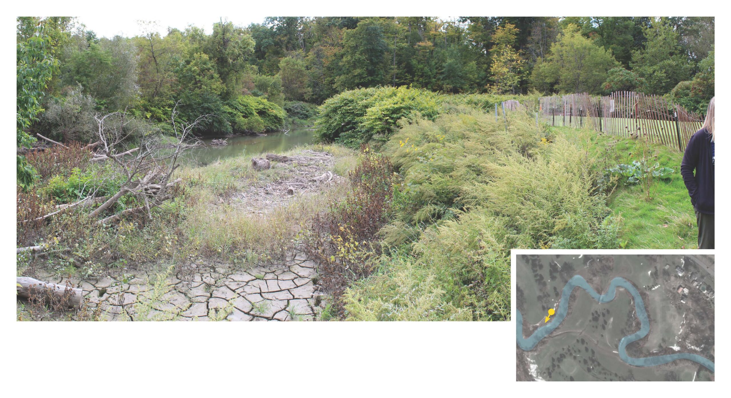
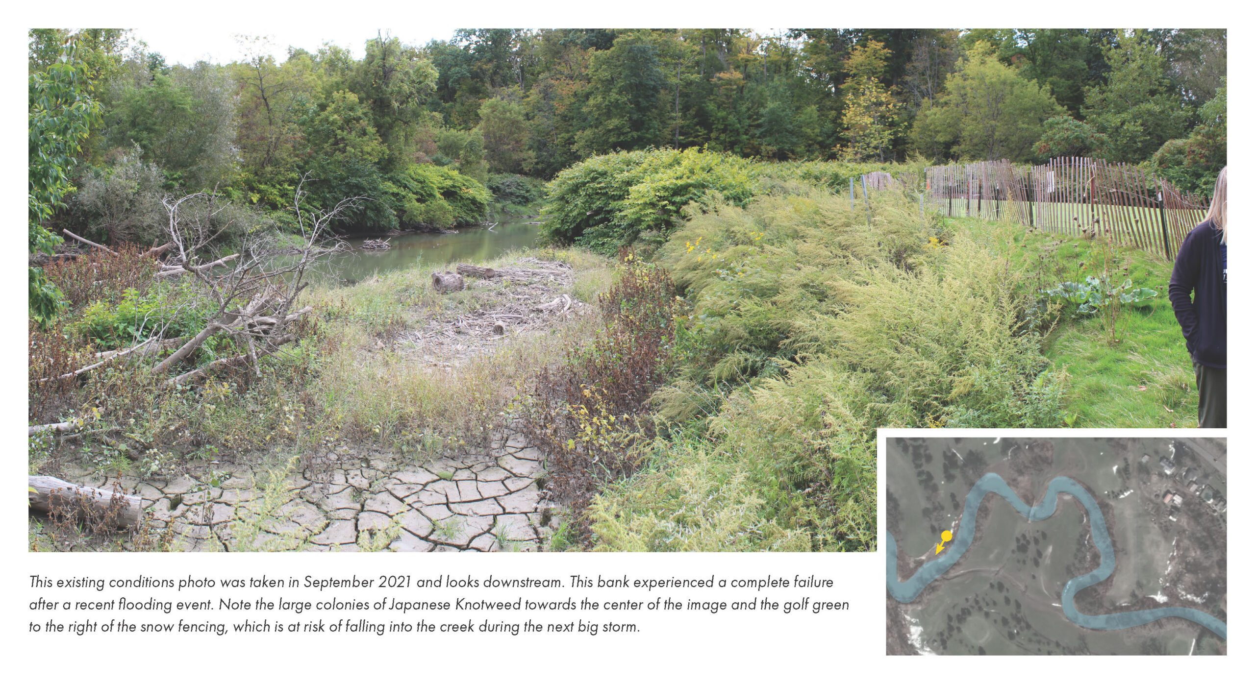
Looking downstream in September 2021. This bank experienced a complete failure after a recent flooding event. Note the large colonies of Japanese Knotweed towards the center of the image and the golf green to the right of the snow fencing, which is at risk of falling into the creek during the next big storm.
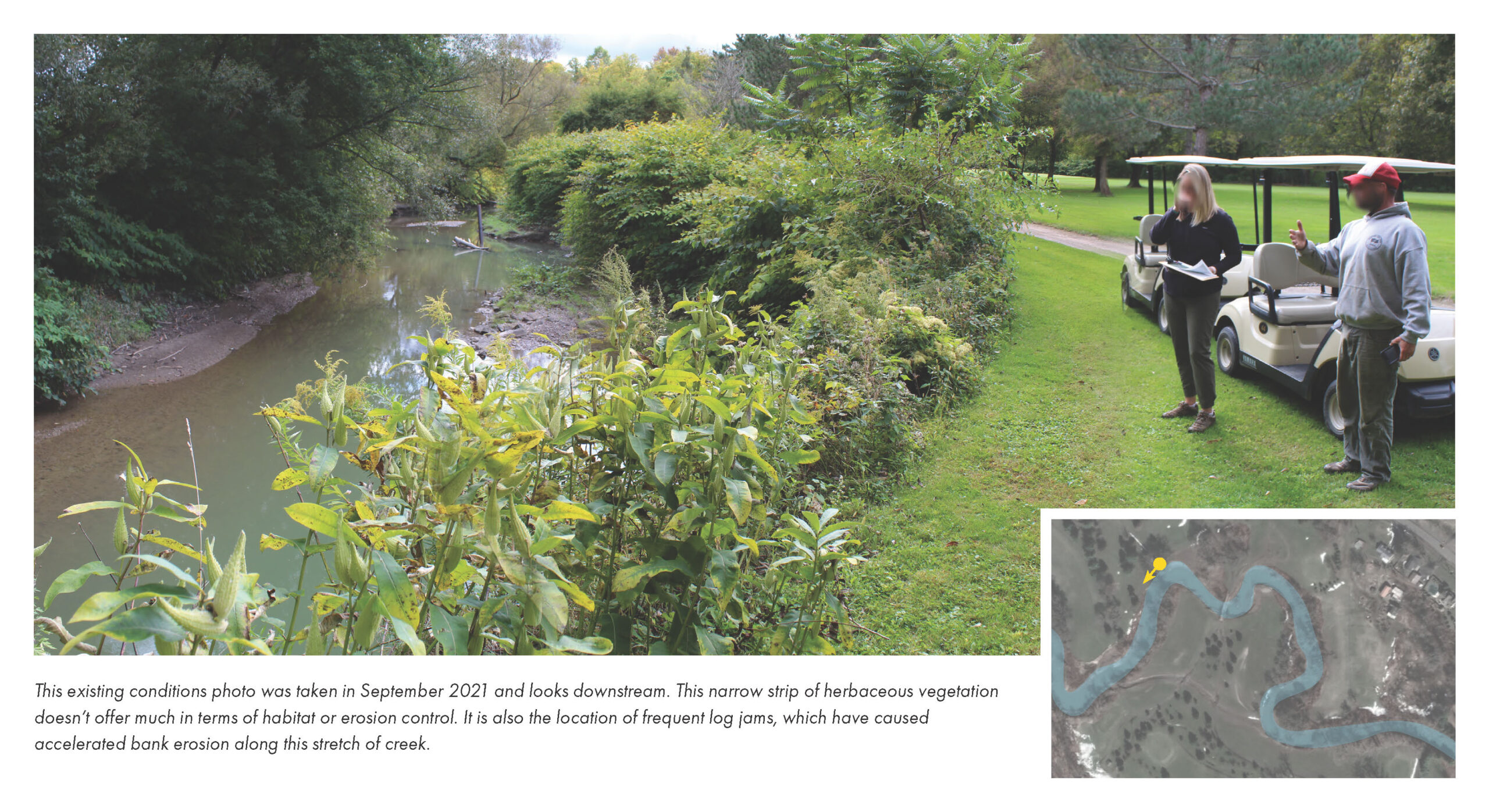
Looking downstream in September 2021. This narrow strip of herbaceous vegetation doesn’t offer much in terms of habitat or erosion control. It is also the location of frequent log jams, which have caused accelerated bank erosion along this stretch of creek.
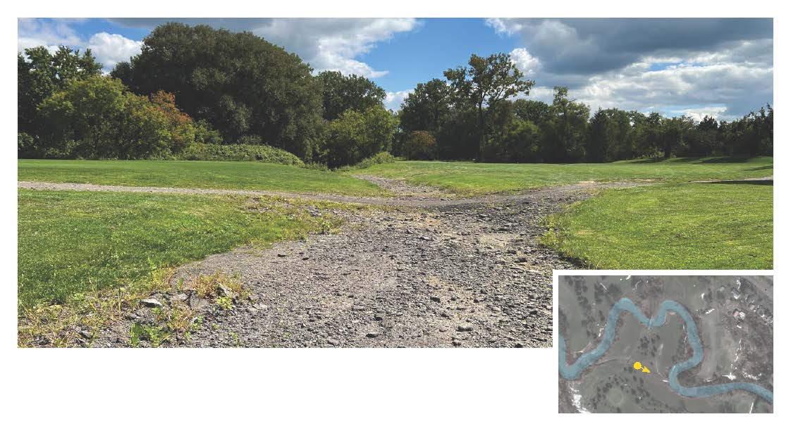
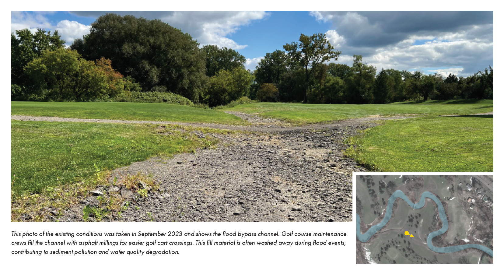
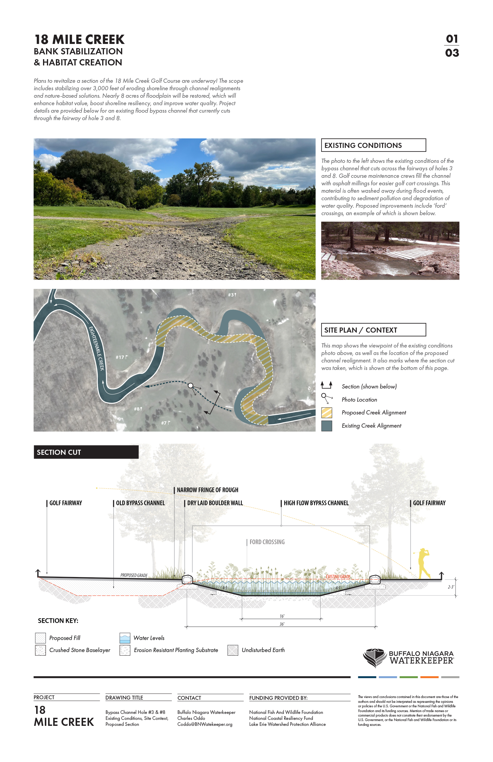
This photo shows the flood bypass channel in September 2023. Golf course maintenance crews fill the channel with asphalt millings for easier golf cart crossings. This fill material is often washed away during flood events, contributing to sediment pollution and water quality degradation.
The images above illustrate shoreline areas along Eighteenmile Creek that are in urgent need of stabilization. Ongoing erosion is damaging greens and fairways and diminishing the creek’s ability to support fish and wildlife habitat.
Increased sediment loading caused by severe erosion is also impairing water quality, further stressing the ecological health of this regionally significant waterway, which supports many fish, bird, and other wildlife species. Addressing these conditions offers an important opportunity to improve golf course conditions while protecting and enhancing a critical natural resource.
*According to the United States Geological Survey, turbidity is the measure of relative clarity of a liquid. When water has high turbidity values, it means that there are a lot of suspended particles in the water column. Very high turbidity levels can negatively impact water quality, and can stress plants, fish, and wildlife living in the shallow water areas along the shoreline.
Preliminary Concepts for Revitalization
This project is currently in the schematic design phase, and BNW is actively pursuing additional funding to support final design and construction of this important project. The scope of work described in the design plans includes stabilizing the shoreline through nature-based solutions and revitalizing floodplain habitat through invasive species removal and native plantings. These improvements will enhance habitat value, shoreline resiliency, and water quality without impacting golf course programming.
Revitalization Impacts at a Glance
850
Linear feet of channel realignment
5,000
Linear feet of bank stabilization
1.3
Acres of wetland creation
7.8
Acres of floodplain enhancement
Preliminary design drawings are shown below. Click any image to enlarge for a closer look at the details.


Satellite map shows the project area with an overlay of design plans.


All these ecological improvements are being designed with the golfer’s experience in mind, ensuring design solutions will enhance the course aesthetic and not impede golf play. There are many compelling project examples of golf courses that successfully balance golf course aesthetics with the ecological health of the surrounding environment. Some of these examples are profiled above. Buffalo Niagara Waterkeeper and the design consultant are referencing these types of projects to help inform project design to ensure the project achieves its ecological goals while also enhancing the golfer’s experience.
Anticipated Project Impacts
The project is still in the design phase; however, BNW is actively pursuing grant funding to support final design and implementation.
After funding is secured and the project is constructed, the site will greatly benefit from the revitalized shoreline conditions. Realigned and stabilized shorelines will be more resilient to storm events and will support a diverse array of native species, providing a wealth of environmental services to the surrounding community. The project will reduce erosion, improve water quality, and benefit the wildlife that rely on healthy shorelines to survive, such as freshwater mussels, various fish species, wading birds, waterfowl, beneficial insects, and pollinators.
- Channel realignments can reduce debris jams and lessen shear stress along creek banks, which will increase bank resistance to erosion during storm events.
- Native vegetation growing along the water’s edge will reduce erosion while absorbing and filtering pollutants and nutrients.
- A variety of native plants not only strengthens the shoreline, but also attracts birds, bats, and frogs, which are natural predators of pest species like mosquitoes.
- Tough native species that thrive in challenging growing conditions are carefully selected, and plant height is scrutinized to ensure ecological benefits are maintained without disrupting golf play.
- Golf cart circulation patterns are adjusted to create more planting opportunities along the shoreline, a natural method for increasing bank stability with plant roots.
- Riparian trees and shrubs also improve aquatic conditions for fish and other aquatic life by casting shade over the water, which helps keep water temperatures cooler during the summer.
- The existing high-flow bypass channel is enhanced with plantings and new ‘ford crossings’, which allow for stabilized channel crossing without compromising the flood conveyance function of this feature.
Partners
This project is made possible through a grant from the National Fish and Wildlife Foundation, with support from the National Oceanic and Atmospheric Administration. Additional support was provided by the Lake Erie Watershed Protection Alliance, with funding provided by the NY State Department of Environmental Conservation’s Environmental Protection Fund.
National Fish and Wildlife Foundation
Funder – Schematic Design
Lake Erie Watershed Protection Alliance
Funder – Conceptual Design
Town of Hamburg
Landowner
18 Mile Creek Golf Course
Project Partner
Wendel
Design Consultant
The views and conclusions contained in this document are those of the authors and should not be interpreted as representing the opinions or policies of the U.S. Government or the National Fish and Wildlife Foundation and its funding sources. Mention of trade names or commercial products does not constitute their endorsement by the U.S. Government, or the National Fish and Wildlife Foundation or its funding sources.