
Help build a shared vision for the protection and restoration of the Scajaquada Creek watershed!
View The 2026 Scajaquada Creek Story Map
Scajaquada Creek Information
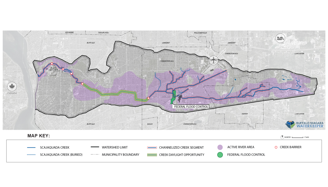
The spring-fed headwaters of the creek are in the Town of Lancaster. The creek flows through the Village of Depew and Town of Cheektowaga before it is buried for approximately 3.7 miles under the east side of the City of Buffalo at Cheektowaga/Buffalo border. Scajaquada Creek daylights in Forest Lawn Cemetery and flows through Buffalo’s Olmsted Park System in the heart of the city. The mouth of Creek at Black Rock Canal and ultimately flows into the Niagara River. The lower Scajaquada Creek is a part of the Niagara River “Area of Concern” and a major tributary in the Great Lakes – the largest freshwater ecosystem in the world.
A Transformative Vision
Scajaquada Creek is a highly impaired waterway in a densely populated watershed. Despite the creek’s impairments, it hosts a resilient ecosystem and serves as a backbone to many valuable public green spaces. Waterkeeper’s hope for a restored Scajaquada Creek corridor is based upon the belief that water is the common thread which binds together community, economy, and ecology. Waterkeeper is committed to working closely with the community and decision-makers to achieve a common vision of creek restoration and community revitalization, and advocate for state, federal, and local resources to be dedicated to Scajaquada Creek.
Active Projects
Riverwatch
The Riverwatch Program consists of concerned citizens trained to use the latest technology to gather important water quality data in the Niagara River Watershed. Volunteers conduct monthly monitoring of streams in their neighborhood and also provide a network of “Eyes on the Water” to report pollution or improper land uses on these waterways.
Past Projects
Drone Footage of Scajaquada
View footage of Scajaquada Creek from the sky. Drone footage captured key parts along its 13 mile journey from Lancaster to Buffalo. And to view other discussions about the creek, click below to watch our Lunch and Learn series from Scajaquada September.
Issues & Impacts on Scajaquada Creek
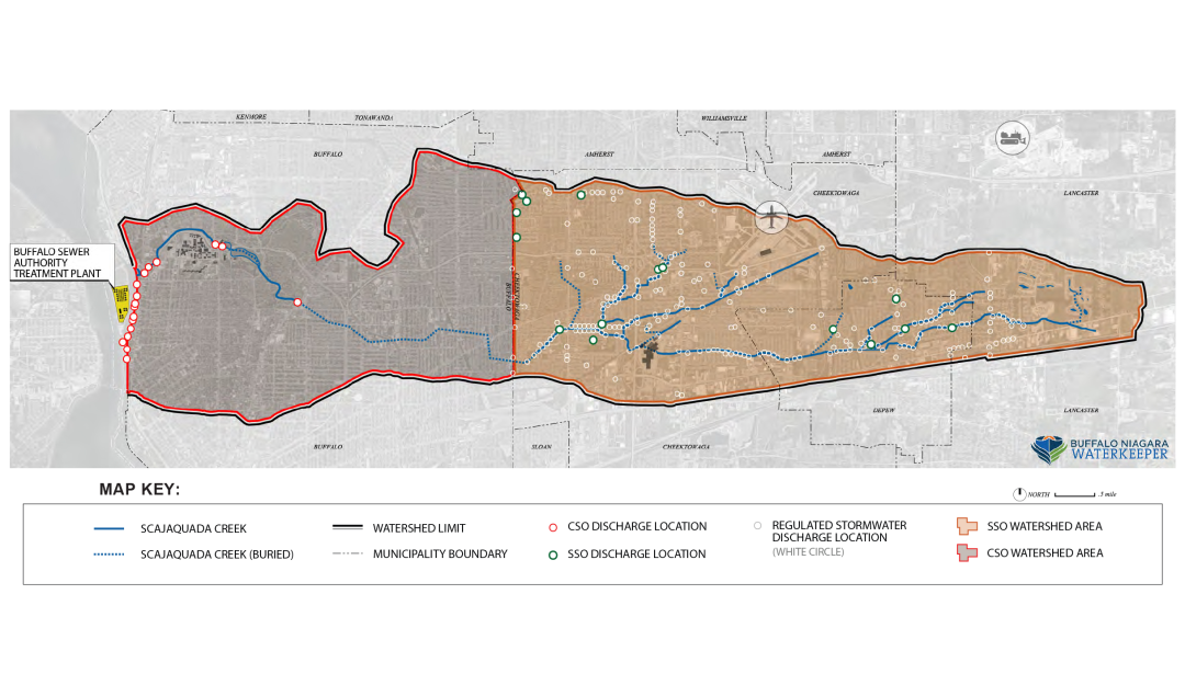
Combined Sewer overflow (CSO)
Buffalo was designed with a combined sewer system. These collect stormwater runoff and sewage in the same pipe to bring to the wastewater treatment facility. To prevent back ups, the systems were also designed with outfalls to allow excess water out of the system. Due to increasing impervious surface (such as parking lots and roadways) and demand on our pipes, heavy rainstorms lead to overflows which discharge the combination of sewage and stormwater directly into waterbodies, like Scajaquada Creek.
Impacted areas: Lower Scajaquada, Scajaquada Drain
Sanitary Sewer Overflow (SSO)
Other sewer systems, like in Cheektowaga and Lancaster, were designed to carry stormwater runoff and sewage through separate pipes. These separated sanitary sewers can still overflow directly into waterbodies due to excess water from sump pumps and connected downspouts. This can also be caused by aging pipes that have cracks in them and take on groundwater. These types of connections to the system are not allowed, but are still in practice in homes that have not been inspected recently.
Impacted areas: Town of Cheektowaga, Lancaster Headwaters
Human Alterations
Over the years, the Scajaquada Creek has been altered to make way for urban development. Due to sanitation and flooding concerns, in the 1920s over three miles of the creek were buried underground in the east side of Buffalo. Wetlands have been drained along the creek. The creek has also been channelized, or straightened, and its path reinforced with concrete. These changes affect the ability of natural processes to maintain good water quality and provide habitat for fish and other species.
Impacted areas: All sections
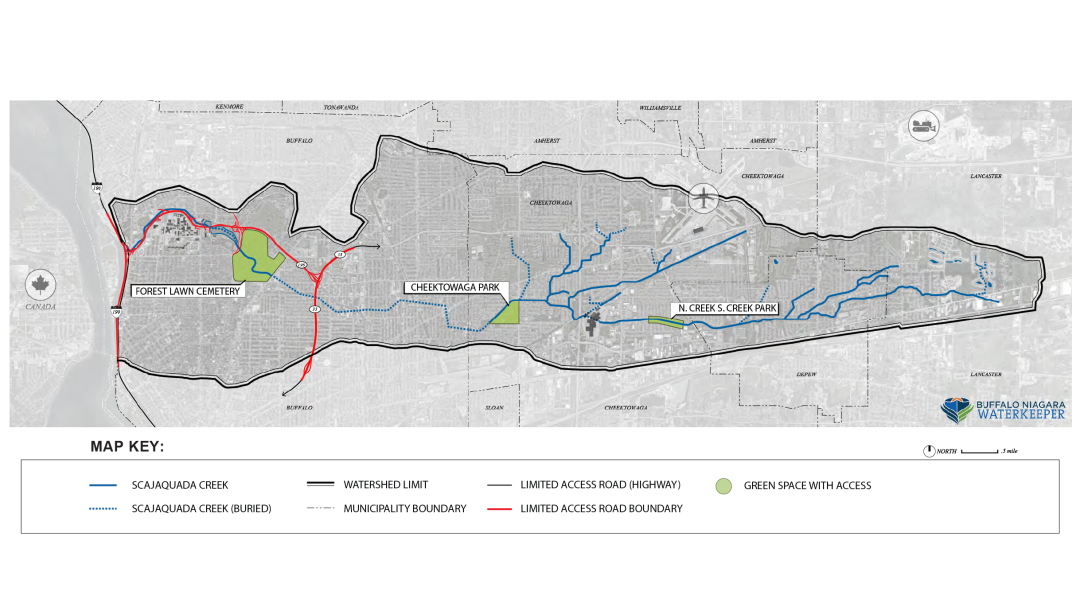
Route 198
The Scajaquada Expressway, Route 198 follows the creek bed from around Delaware Park through to its mouth. Pillars holding up the elevated portions and ramp connecting to I-190 are built directly into the creek bed. This poses barriers to public access as well as threatens water quality from direct runoff, salt, silt and other debris that collects on the raised highway.
Impacted areas: Lower Scajaquada
Visualizing the Issues
Keeping Time on
Scajaquada Creek
Pre-1800s. Conjockety
The name Scajaquada comes from the Native American name Conjockety, or Kenjockety, who was known as the “last survivor” of the Neutral Nation that lived at Black Rock.
1812. War of 1812
The mouth of Scajaquada at Black Rock was the site of America’s first Naval Shipyard, used in the War of 1812 to fight off the British invading from Canada.
1880s. Olmsted
Fredrick Law Olmsted designed Delaware Park, and “Gala Water,” known later as Delaware Park Lake and Hoyt Lake, by damming Scajaquada Creek.
1901. Pan-American Exposition
The 1901 Pan-American Exposition was held on the shores of Scajaquada Creek and Delaware Park Lake.
1920s. Scajaquada Drain
As a reaction to extreme pollution that saw Scajaquada Creek being labeled a “public nuisance” , nearly four miles of Scajaquada Creek was buried at an average depth of 8 feet, to remove the problem from sight.
1960s. Expressway
A national trend saw cities everywhere constructing limited access highways through neighborhoods in order to shuttle commuters from suburban locations to jobs in the City. In the 1960’s the NYS RT 198 was constructed through neighborhoods, Buffalo’s crown jewel Delaware Park, and directly on top of Scajaquada Creek.
1970s. Flood Control
Massive flooding driven by hydrologic modification of the creek and changing land use occurred in Scajaquada Creek in 1937, 1942, 1945, 1963, and 1967, spurring the USACOE to construct a large flood control basin in Cheektowaga.
1980s. Increased Development Pressures
Development in the headwaters of Scajaquada Creek increased rapidly after the construction of the flood control project, and the Galleria Mall, which straddles the creek in Cheektowaga, and further drained and diverted the remaining wetlands.
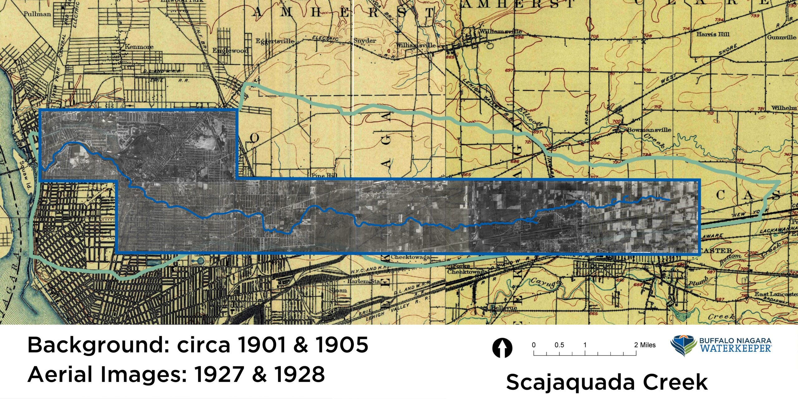
Historic Images
Check out ariel images taken in the 1920s to view how the creek once looked. All photographs are from Erie County website.
Clicking the image will take you to a PDF and the ability to click on a photograph to enlarge each image.
Links to Scajaquada Creek Articles
Check out these articles from Buffalo Rising.
Before Us Stands the Last Chance in a Generation to Reclaim Our Creek and Community
July 22, 2021
Bring Em Down Kensington and Scajaquada Expressways Featured in the Architects Newspaper
June 14, 2021