
New York State is a Great Lakes State! This is a fact many forget, as New York also has a coastline along the Atlantic Ocean.
We are so lucky to have so much freshwater on our doorstep here in Western New York. Water is life. Even with this abundance of water, many communities have become disconnected from our water resources. This may stem from physical barriers, a lack of access or missed outdoor experiences in early childhood. Rekindling these connections to our waterways is folded into our mission, and a key component to our educational programming. So let’s take a dive into a water concept that causes much bewilderment: the watershed.
What Is a Watershed?
A watershed is an area of land that drains into a river, lake or other bodies of water.
Think of it as a bathtub. If water flows into the bathtub, it will travel towards the drain. If water escapes the bathtub, the water will flow elsewhere. The bathtub is your watershed, and the drain is a receiving waterway. And you can imagine that a tributary is a faucet filling the bathtub.
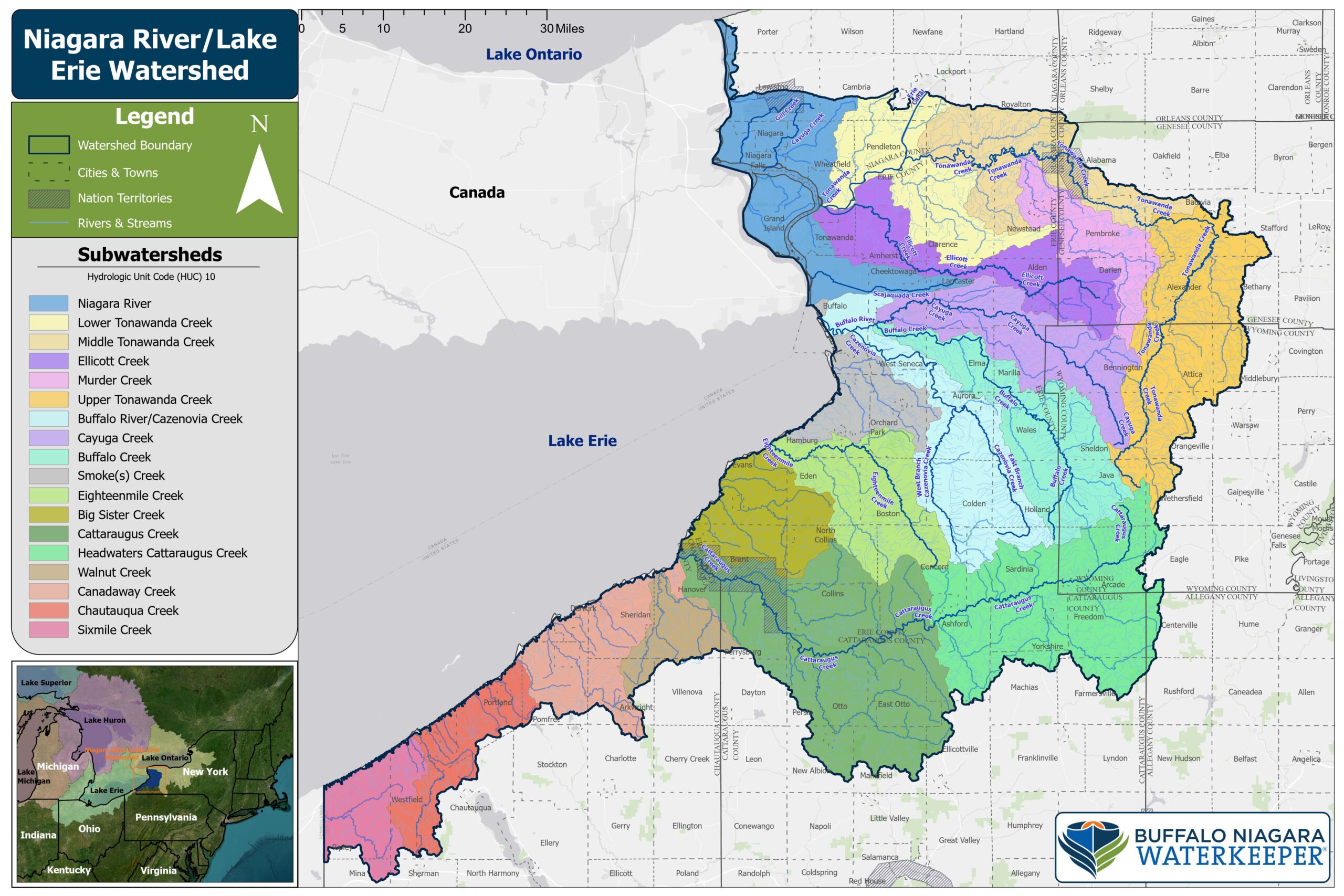
The Niagara River/Lake Erie Watershed is:
Located along the westernmost portion of New York State and encompasses lands that drain into Lake Erie and the Niagara River - a channel that connects the Great Lakes of Erie and Ontario.
Part of the larger Great Lakes Drainage Basin.
Encompasses 1.5 million acres of land, 116 municipalities, 5,543 miles of rivers and streams, and 145,000 acres of state and federally listed wetlands.
Explore an interactive map of the watershed here
Subwatersheds in the Niagara River/Lake Erie Watershed
Buffalo Creek
Buffalo Creek may have the most miles of high quality, headwater trout streams.
Six wetland areas occur in the headwaters; several are hydraulically connected to the underlying aquifer and support heritage strains of brook trout. Queen snake and two listed species of freshwater mussel, fragile papershell and slippershell, are found in mid-reaches. Upland and mid-reaches have significant tracts of natural land, including three County forests plus the 384-acre Beaver Meadow Audubon Center and the 789-acre Hunter’s Creek County Park.
Buffalo River
The Buffalo River sub-basin varies across ecoregions
From high quality upland forests and streams down to the urban-industrial corridor and “Area of Concern” approaching Lake Erie. Headwaters include the East and West Branches of Cazenovia Creek, which rise in the Towns of Sardinia and Concord respectively, and flow northwest to join in the Village of East Aurora. This sub-basin has 31 tracts of riparian forest greater than 50 acres in size and at least 100 meters in width from water’s edge, and 49 tracts of unbroken core forest greater than 500 acres. As with streams originating in the Cattaraugus Hills, the cold Buffalo River headwaters support trout and other aquatic communities of statewide significance, (Hunt, 2002) but are compromised by barriers limiting fish passage.
Canadaway Creek
The heavily forested sections of Canadaway Creek supports trout streams and hundreds of bird species
Canadaway Creek flows through Dunkirk and Fredonia before entering Lake Erie. The stream was originally settled by the Erie tribes and later by the Haudenosaunee who called the stream “Ga-na-da-wa-o,” meaning “running through hemlocks.” The early European settlers from Eastern and Central Pennsylvania ended up pronouncing the name as “Canadaway.”
Chautauqua Creek
Chautauqua Creek boasts the highest catch rate for Steelhead Trout of any New York River
Chautauqua Creek flows through steep-sided gorges, covering 80.1 square miles of forested and rural land. It then passes through the Village of Westfield and into Lake Erie. Efforts are currently underway to remove several fish barriers along the creek and allow fish species to travel further upstream.
Cattaraugus Creek
The largest of the subwatersheds, containing over 800 miles of waterways.
Cattaraugus Creek begins in the uplands of the Allegheny Plateau before cutting through Zoar Valley, a stunning gorge known for its cliffs and biodiversity. The creek supports a diverse ecosystem, including Steelhead trout species, which migrate upstream for spawning. The region’s steep slopes and forested areas are vital for wildlife conservation. Cattaraugus Creek is split into two separate subwatersheds, with the Headwaters subwatershed being the second largest.
Cayuga Creek
Cayuga Creek includes Little Buffalo, Slate Bottom and Plum Bottom Creeks as tributaries for a total of 356 stream miles.
It begins in primarily farmland/wooded areas in higher elevation Wyoming County and passes through several residential areas before its confluence with Buffalo Creek near Cheektowaga. In Cheektowaga, Reinstein Woods Preserve and Stiglmeier Park include the freshwater wetlands of Cayuga Creek and the Creek itself. In Lancaster, Como Lake County Park also includes portions of Cayuga Creek.
Eighteenmile Creek
Eighteenmile Creek is a large, meandering stream whose upland forests and spring-fed headwater tributaries are part of a functional landscape providing natural overhanging cover, material contribution and good water quality to the system.
Mid-reaches of both the main stream and principal tributary, South Branch, flow through steep-sided, undeveloped, wooded gorges with 70-150 foot high shale cliffs, cold springs and seeps, and talus communities of probable biodiversity significance. The lower half-mile is low gradient, 75-100 feet wide, with a broad floodplain, including potential patches of clayplain forest and/or limestone woodland with abundant swamp white oak.
Ellicott Creek
Ellicott Creek flows northwest from headwater wetlands in the Town of Darien (southwest corner of Genesee County) to the City of Tonawanda where it joins Tonawanda Creek about a half mile above its mouth at the Niagara River.
While the upper reaches (upstream of Transit Rd.) are less developed; the lower reaches flow through the residentially and commercially developed Towns of Lancaster, Amherst and Tonawanda.
Headwaters Cattaraugus Creek
Rolling Hills and Forested Valleys account for the diverse landscape within the Cattaraugus Headwaters.
Headwaters Cattaraugus Creek contains the upper portions of Cattaraugus Creek. This subwatershed features forested tributaries and wetlands, which help maintain biodiversity and water quality. The headwaters play a crucial role in groundwater recharge, supporting both local ecosystems and human water needs.
Lower Tonawanda Creek
From the Village of Pendleton to its mouth on the Niagara River, the last 11.6 miles of Tonawanda Creek is channelized and dredged to a width of 75 feet and a depth of 12 feet to accommodate the Erie Canal.
From April through November, a lock diverts Lower Tonawanda Creek to flow backward approximately 19 miles northeast through the canal to Lockport.
Middle Tonawanda Creek
From the City of Batavia to the Village of Pendleton, Middle Tonawanda Creek includes parts of seven towns and the Tonawanda Seneca territory.
Its northern border is formed by the Niagara Escarpment and its southern, in part, by the Onondaga Escarpment which the creek crosses at Indian Falls. In the 20‐mile stretch from Indian Falls downstream to the Village of Pendleton, where the creek meets the Barge Canal, Tonawanda Creek’s broad floodplain and many wetlands are a remnant of glacial Lake Tonawanda.
Murder Creek
Murder Creek is its own sub-watershed and the major tributary to Middle Tonawanda Creek.
Located primarily in the southwestern portion of the Genesee County, Murder Creek also includes many low-lying areas and meanders through the Towns of Pembroke and Newstead.
Niagara River
Biodiversity features and conservation opportunities in the Niagara River sub‐basin vary according to three major geographies:
The Upper River including the stream drainages above Niagara Falls; the Lower River, including the Niagara Gorge; and the natural (unpopulated) islands. Niagara Falls was the historic natural barrier between the four Upper Great Lakes and the Lower Lake Ontario-St. Lawrence River system. The Niagara River has the most biodiversity in the Niagara River Watershed. The Niagara Gorge, once considered one of the most botanically diverse places in North America, still supports many rare plants and communities.
Smoke's Creek
Smoke’s Creek rises in the Town of Orchard Park and flows northwest for 15 miles to its mouth on Lake Erie.
Its one principal tributary, South Branch, is 12 miles long. The creek is named after “Old Smoke,” a Seneca leader whose son traditionally carried the fire—the “smoking brand”—from the Haudenosaunee or Iroquois Confederacy Council fire at Onondaga to the Seneca Nation council fire in Western New York. Old Smoke lived near this creek in his later years and was buried here.
Sixmile Creek
The southernmost subwatershed, with portions in both New York and Pennsylvania.
Sixmile Creek has areas prone to flooding, especially after heavy rainfall, making flood management a priority. The largest stream in the subwatershed is Twentymile Creek, which starts in New York and flows into Pennsylvania before emptying into Lake Erie. While the subwatershed has sections in Pennsylvania, Buffalo Niagara Waterkeeper’s boundary ends at the New York State line.
Upper Tonawanda Creek
From its source in the Towns of Wethersfield and Java the creek flows north through the Towns of Alexander and Batavia where the terrain levels out and the active floodplain broadens.
The main branch, Little Tonawanda Creek, joins Tonawanda in the Town of Batavia. At the City of Batavia, the Onondaga Escarpment blocks further flow north and the creek turns west towards the Niagara River. The confluence with another tributary, Bowen Creek, marks the northwestern boundary of the Upper Tonawanda Creek Subwatershed.
Walnut Creek
Walnut Creek is the smallest subwatershed within the Lake Erie/Niagara River watershed
Walnut Creek covers 56.3 square miles and flows through a primarily rural landscape in the Town of Hanover before emptying into Lake Erie. The creek supports important wetland areas that filter water and provide habitat for fish and amphibians and serve as breeding grounds for several species.
Active Projects
Riverwatch
The Riverwatch Program consists of concerned citizens trained to use the latest technology to gather important water quality data in the Niagara River Watershed. Volunteers conduct monthly monitoring of streams in their neighborhood and also provide a network of “Eyes on the Water” to report pollution or improper land uses on these waterways.